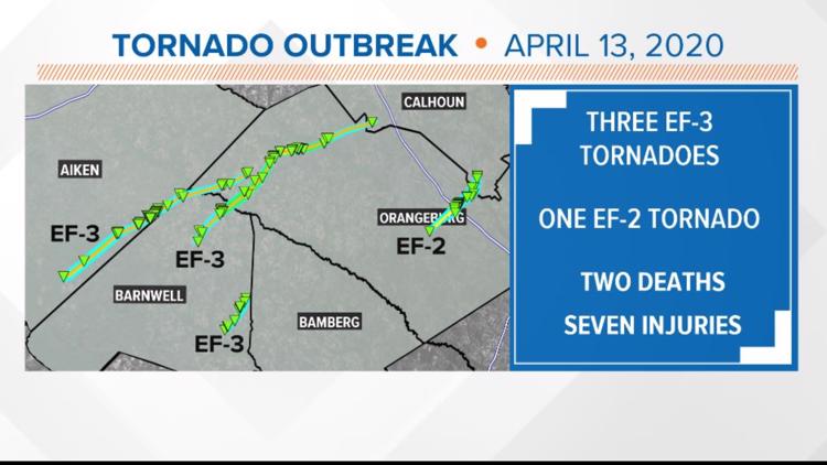
COLUMBIA, S.C. — More strong tornadoes were confirmed by the National Weather Service in Columbia from Monday morning's severe weather outbreak.
So far, the survey teams from the weather service have confirmed three EF-3 tornadoes and one EF-2 tornado.
Teams from the National Weather Service are still surveying damage Wednesday. There could be more confirmed tornadoes from Monday's storms.
Another EF-3 tornado confirmed:
The National Weather Service in Columbia has released more information on the EF-3 tornado that moved through parts of Aiken, Barnwell and Orangeburg counties. This is in addition to the EF-3 tornado that took the lives of two people in Orangeburg.
Like the previously confirmed twister, the second tornado had maximum winds of 140 mph.
The maximum path width was 800 yards and it traveled 30.19 miles. There were no deaths or injuries reported with this tornado.
Summary track:
The strong, long-track tornado began in the Savannah River Site, then moved in a general northeast direction in Aiken County near the Barnwell County border.
The tornado crossed into Barnwell county northwest of Williston near Davis Bridge Road. The tornado continued northeast across northern Barnwell County and crossed into Orangeburg County and dissipated northeast of Springfield.
The tornado path length was approximately 30 miles, and at its widest point was just under 0.5 miles. The tornado rating was an EF-3, with peak wind speeds of 140 mph.
The tornado strengthened as it moved out of the Savannah River Site, producing its most significant damage near Williston Road and Jaywood Road west of Williston. In this area, significant roof damage and a partial wall collapse to a brick house occurred, with a small cinder block workshop destroyed.
The tornado then destroyed a vacant store building, and removed the roof and some of the walls of a metal auto shop building. Nearby trees were all snapped near the base. The tornado then destroyed a brick shed and removed most of the roof off a home along tinker creek road. A mobile home was shifted about 6-10 feet off its foundation along Cherry Tree Road.
The tornado then completely destroyed a manufactured home on Tinker Creek Road near Charleston Highway and snapped a significant number of trees in that area.
The tornado then crossed Charleston Highway, removing a large portion of the roof and collapsing an exterior wall of a business. The tornado continued to snap and uproot countless trees as it crossed Davis Bridge Road and New Forest Road in northern Barnwell County.
The tornado moved into Orangeburg County, uprooting many large trees in the town of Springfield, some of which fell on homes and one on a church.
The tornado finally dissipated northeast of Springfield, just before reaching the path of another EF-3 tornado just to the east.
A third EF-3 tornado was confirmed. This one moved through Barnwell County:
The National Weather Service in Columbia has released more information on the EF-3 tornado that moved through Barnwell County.
This EF-3 tornado had maximum winds of 145 mph.
The maximum path width was 800 yards and it traveled 5.45 miles. There were no deaths or injuries reported with this tornado.
Storm track/summary:
A tornado touched down in far southeast Barnwell moving northeastward toward the Bamberg county line southeast of the town of Hilda, briefly intensifying to a strong tornado along Hartzog Road.
The tornado length was 5.5 miles and had a width of 800 yards at its widest point. The tornado was rated EF-3, with peak winds of 145 mph.
The tornado began just north of Highway 64 at Green Branch Road near Indigo Road. The tornado moved northeast across Hercules Creek and caused significant tree damage at a residence on Friendship Road. Several oak and pine trees were uprooted and snapped.
A cinder block garage had its metal roofing peeled off and the wind stress shifted the cinder blocks about half way up the wall. Along its northeastward path, there was continued tree damage but the tornado strengthened rapidly as it crossed Hartzog Road just south of November Road.
A well built bolted down metal building structure and tin tractor shed was completely destroyed. Further north along Hartzog Road, a residence had part of its roof lifted off and behind the residence, a two story wood frame building was shifted off its foundation and destroyed and an unanchored log cabin was destroyed.
As the tornado moved northeast toward Huckleberry Bay Road there were multiple hardwood trees snapped near the base of the trees. The tornado began to weaken as it crossed Old Salem Road continuing to damage trees along its path before dissipating just north of Huttos Chapel Road.
A strong EF-2 tornado was confirmed. This one moved through Orangeburg and parts of Calhoun County:
The National Weather Service in Columbia released more information on the EF-2 tornado that moved through Orangebrug County and into Calhoun County.
This EF-2 tornado had maximum winds of 119 mph.
The maximum path width was 700 yards and it traveled 10.29 miles. There were no deaths or injuries reported with this tornado.
Summary/Track:
A tornado touched down in Oangeburg County about 4 miles northeast of Rowesville and tracked northeastward across Interstate 26 and Highway 301.
EF-0 damage occurred from the intersection of Garland and Bethel Forest Road, where the tornado started, to just prior to crossing I-26.
The tornado strengthened producing EF-1 damage across agricultural fields and in the Orangeburg Industrial Park.
As the tornado crossed I-26 it further strengthened to EF-2 then crossed Highway 301. The tornado rapidly weakened to EF-1 then just north of Highway 301 and further to EF-0 as it moved into the middle Pen Swamp.
Through the remainder of the tornado path it cycled between EF-1 and EF-0 then finally lifted just north of the intersection of
Houcks Gin Road and Old State Road. The total tornado path length was 10.3 miles with a maximum width of 700 yards. The tornado caused numerous hardwood and softwood trees to be snapped along the path and overturned multiple pivot irrigation systems.
Damage was done to a tractor dealership with the front windows being shattered and the overhead doors being blown in by the wind. Several of the snapped and uprooted trees were blown onto structures causing roof damage to residential and industrial structures.
Damage to grain silos and outbuildings on the north side of Highway 301 was estimated by the owner to be $1 million.
According to the National Weather Service in Columbia, our area has not had more than three EF-3 or higher tornadoes since the March 28, 1984 outbreak.
Survey crews are still working assessing the damage. More tornadoes may be confirmed.