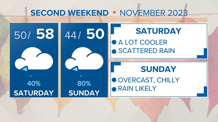
COLUMBIA, S.C. — A few stray showers are possible today, light rain is expected Saturday, but heavier rain will impact the Midlands Sunday. Temperatures will be substantially colder over the weekend.
Later this afternoon and evening, a strong cold front is predicted to move in, bringing with it much colder and wetter weather for the weekend as a cold air wedge forms. On Saturday, temperatures will drop significantly below average, and as Sunday approaches, there will be more widespread rain. By Monday night, the wedge will disintegrate, and by the middle of the following week, more normal conditions are predicted.
Today, the clouds are going to move into the Midlands. Although there is a chance of an isolated shower, today's rainfall is probably going to be minimal. Early this afternoon, highs will peak in the middle to upper 70s.


The clouds will remain in place tonight due to the persistent southwesterly flow that is bringing moisture over the drier air that is developing and moving in close to the surface. After a mostly dry evening, the next disturbance moving in from the southwest will cause a second increase in the chance of rain during the night. Throughout the period, the western Midlands will have the best chance of seeing accumulating precipitation, but overall amounts should stay low. Overnight lows will be in the upper 40s to lower 50s.
Over the weekend, a cold front will be located far to the south of the Midlands, and high pressure centered to the north of the area will start to move southward along the Appalachians. Meanwhile, overhead, the upper pattern remains somewhat southwesterly. This permits moisture to float on top of the surface wedge that is forming by Saturday afternoon and for the majority of Sunday.
Rainfall chances will increase from south to north during the day on Saturday. The amount of rain on Saturday is still expected to be light, but on Sunday, a deeper moisture front may pass through the area, making heavier rainfall amounts possible.

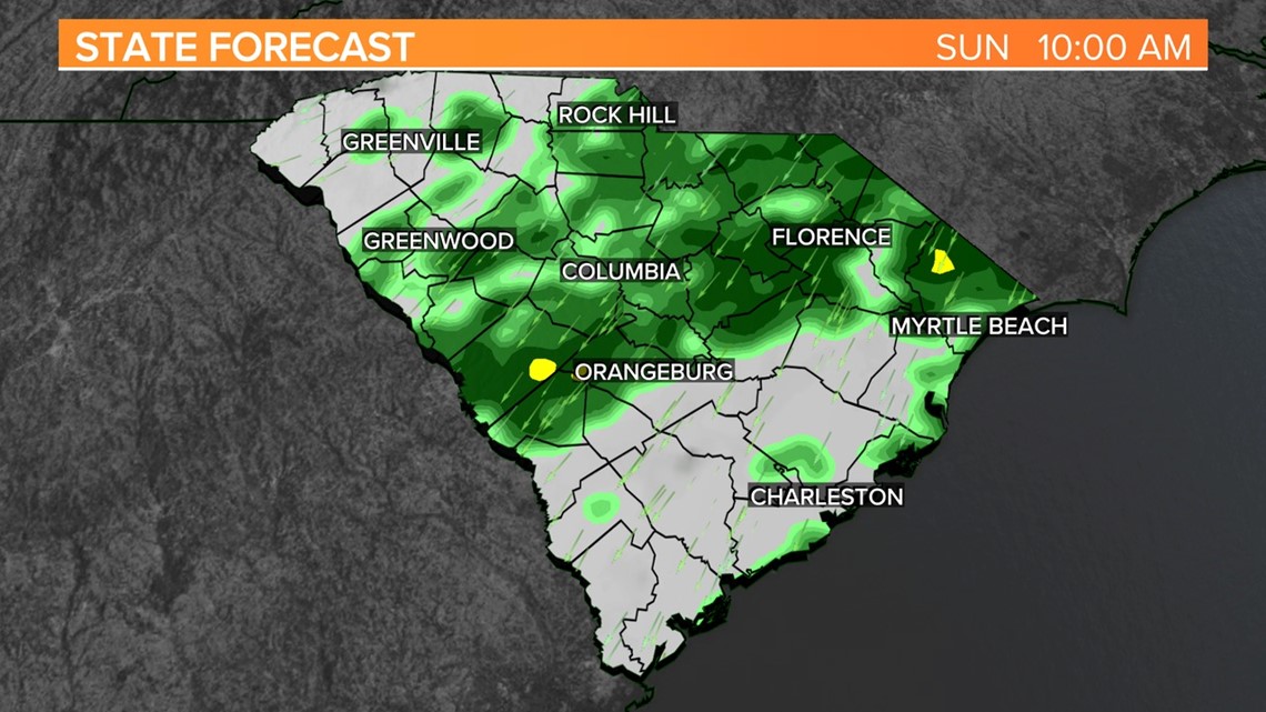
As the upper pattern starts to shift more out of the northwest, drier air will start to move in from the north by Sunday night. This should lessen the likelihood of rain on Sunday night. In terms of temperature, things will get considerably colder every day.
On Saturday, afternoon highs will have difficulty rising into the mid-50s. With a well-established wedge predicted to be in place and rainfall expected into the wedge, Sunday will be even colder. Highs will mostly be in the lower 50s, though many places may spend the majority of the day hovering around 50 or in the upper 40s.