

COLUMBIA, S.C. — Most of the Midlands is under a heat advisory due to heat index values reaching 105–110 degrees this afternoon. A few showers and thunderstorms are possible in the afternoon and evening.
A heat advisory is in effect for most of the Midlands today. Heat index values may climb to 110 degrees this afternoon for parts of the area. The heat advisory for today is through 7 p.m., this includes Kershaw, Lexington, Richland, Lee, Sumter, Calhoun, Clarendon, and Orangeburg counties.
Heat Safety Tips
- Stay Hydrated and Cool: Drink plenty of fluids and stay in an air-conditioned room. Avoid being outside in the sun for extended periods. Check on relatives and neighbors to ensure they are safe and comfortable.
- Protect Children and Pets: Never leave young children or pets in unattended vehicles. Car interiors can reach deadly temperatures within minutes.
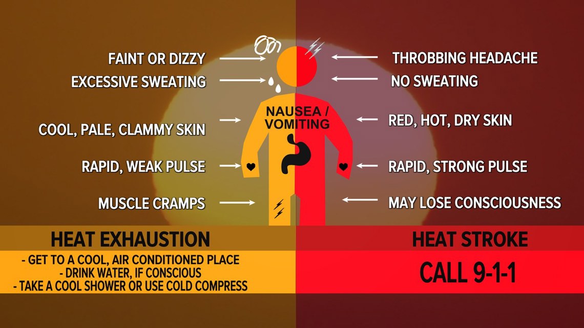
- Outdoor Precautions: When outside, wear lightweight and loose-fitting clothing. Try to limit strenuous activities to the early morning or evening. Be alert to signs of heat exhaustion and heat stroke, and act immediately if symptoms appear.
- Workplace Safety: The Occupational Safety and Health Administration (OSHA) advises taking frequent rest breaks in shaded or air-conditioned areas during outdoor work. If someone has been overcome by the heat, move them to a cool, shaded location. A heat stroke is a medical emergency; call 911 immediately.

Isolated to scattered showers and thunderstorms are expected this afternoon and into the evening. Similar coverage to yesterday is anticipated, with potential instability and low shear. Strong winds are possible with a few of the storms. Activity should decrease after sunset.
The forecast includes increased chances of showers and thunderstorms and continued hot and humid conditions over the next couple of days. High pressure offshore will maintain southwest winds, bringing steady moisture into the area.
Precipitable water levels will remain high, leading to numerous showers and thunderstorms each day. Temperatures will peak in the middle to upper 90s, with heat index values in the low 100s but staying below heat advisory levels.

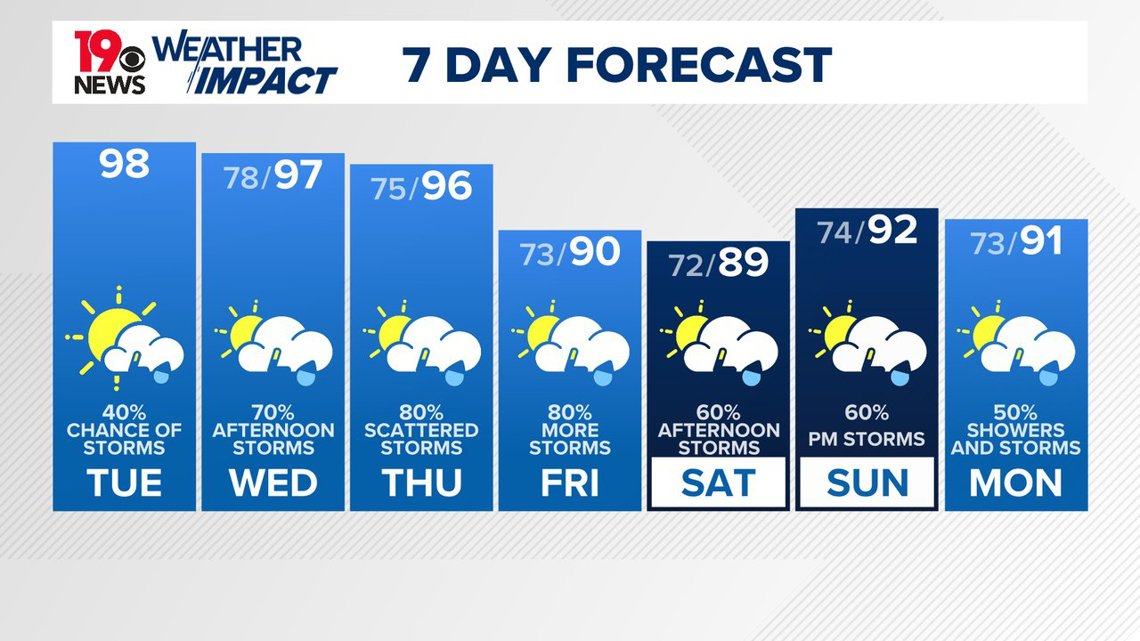
A front moving in from the northwest on Wednesday, along with a weather system moving south from the Great Lakes, will increase shower and thunderstorm activity. Slow-moving storms in a saturated environment may cause localized heavy rainfall and flooding. Similar conditions are expected on Thursday, with more organized storms possible due to better atmospheric dynamics. Overnight lows will stay mild, in the mid-70s on Wednesday night and the low 70s on Thursday night after the front passes.
Abundant moisture will continue to produce scattered to numerous showers and thunderstorms daily. Some storms could be strong, with gusty winds and heavy rain. Temperatures should cool to the low 90s due to increased cloud cover and the breakdown of the upper weather system over the Deep South. Active weather periods may continue over the weekend into early next week, though the exact timing is uncertain.