

COLUMBIA, S.C. — Hurricane Idalia made landfall early Wednesday morning as a Category 3 storm. It had winds of 125 mph as it moved onshore near Keaton Beach, Florida, at 7:45 a.m.
Hurricane-force winds extend up to 25 miles from the center, while tropical-storm-force winds extend up to 175 miles.
Although Idalia will weaken further now that the center has moved inland, it is still expected to be a hurricane as it moves across southern Georgia and near the coasts of Georgia and southern South Carolina later today. Idalia is expected to become a tropical storm tonight and Thursday as it moves near the coasts of northeastern South Carolina and North Carolina.

The center of Idalia is expected to move into southern Georgia later today, with a north-northeastward motion expected throughout the morning. Idalia is expected to turn northeast and east-northeast, passing near or along the coasts of Georgia, South Carolina, and North Carolina late today and Thursday.
Parts of eastern Georgia and southeast South Carolina where hurricane warnings are in effect are likely to experience damaging hurricane-force winds.
Flash, urban, and moderate river flooding, with significant consequences, is expected from the Florida Big Ben through central Georgia and South Carolina, and into eastern North Carolina on Thursday.
South Carolina Impacts:
Flooding:

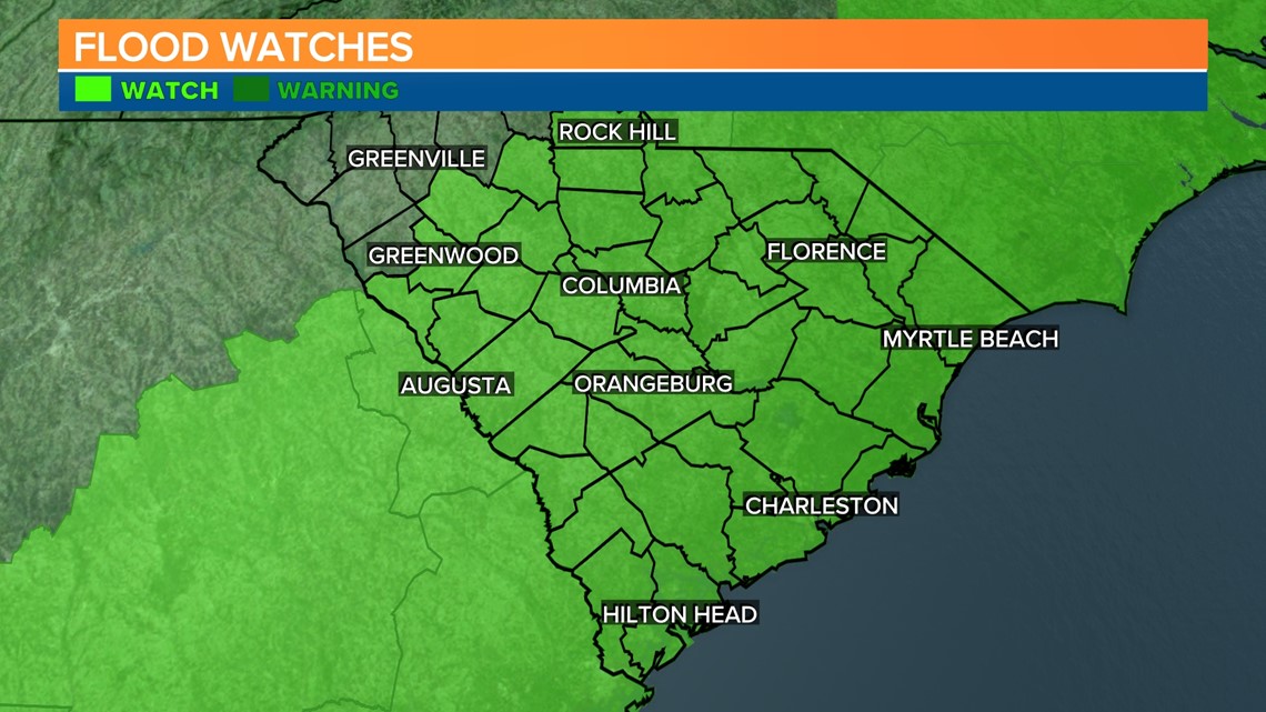
A flood watch remains in effect from 2 p.m. today through Thursday afternoon. This includes all of the Midlands and most of the Palmetto State.
Hurricane Idalia will bring heavy rainfall to the Midlands and Central Savannah River Area this afternoon into early Thursday morning. Rainfall amounts will range from 2 to 3 inches across the western Midlands and the northern Central Savannah River Area.

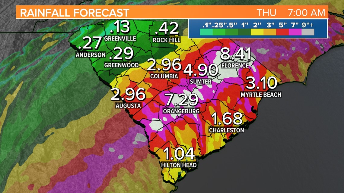
The intensity of rainfall increases into the afternoon, when heavy rainfall rates are expected for several hours as Idalia moves through the region. Total rainfall amounts range from 3 to 8 inches, with locally higher amounts expected.
The majority of this rainfall is expected to fall within a 12-hour period this afternoon and into tonight, which could cause some significant flooding in flood-prone areas. The forecast has shifted where the heaviest band of rain is expected slightly to the east.
Tropical-storm-force winds:

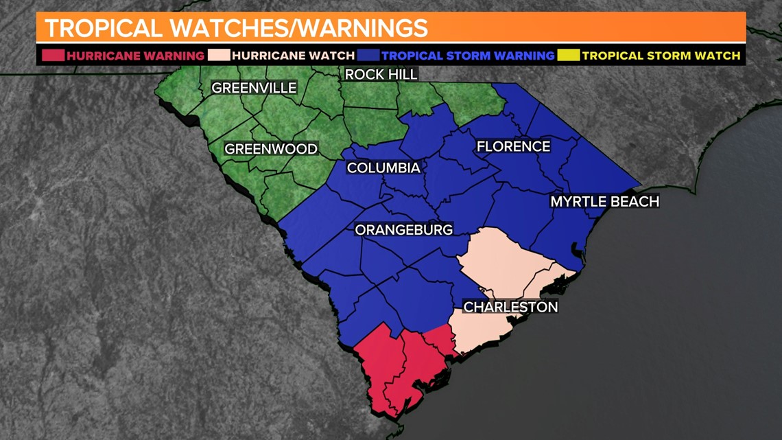
A tropical storm warning is in effect for Aiken, Calhoun, Central Orangeburg, Clarendon, Northwestern Orangeburg, Richmond, Southeastern Orangeburg, and Sumter counties.
A Tropical Storm Watch is in effect for Kershaw, Lee, Lexington, and Richland counties.
Strong winds with gusts of 40 mph or greater are likely in the eastern Midlands, and concern remains about wind gusts exceeding 40 mph in the central Midlands.
With the saturated soils and expected heavy rainfall, these gusty winds could cause topple
trees. In addition to potential tree damage, power outages are possible, especially for the south and east of I-20. The main timeframe for the gusty winds is this evening into tonight.
Tornadoes:

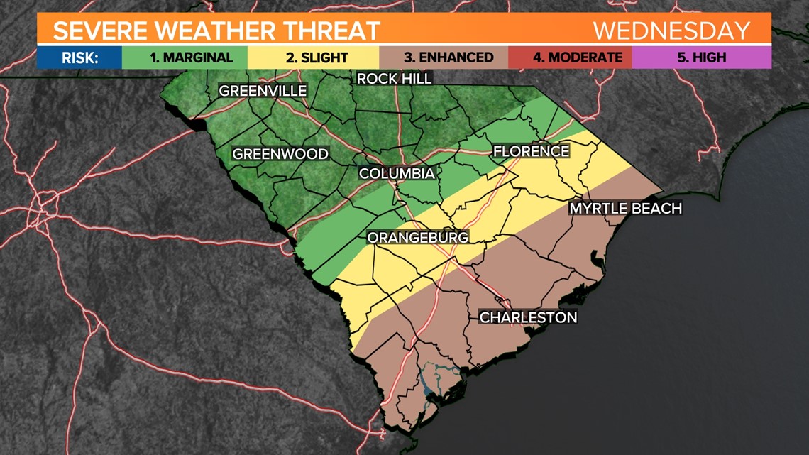
Tornadoes will be possible in the eastern and southern parts of the Midlands. The Storm Prediction Center has this part of the Midlands under a slight risk (2 out of 5) for severe weather.
The Coastal region of the state is at enhanced risk (3 out of 5) for severe weather.
There are currently no tornado watches in effect for South Carolina, but that will likely change later today.
It is important to note that the forecast track and intensity can still change, which could result in changes to any of these impacts.