COLUMBIA, S.C. — Tropical Storm Josephine has formed in the Atlantic, becoming the 11th named storm of this already very active hurricane season.
The National Hurricane Center announced Thursday morning that Josephine has strengthened and developed enough to be considered a tropical storm. It continues a record-setting year in the tropics, as this is the earliest "J" storm on record since storms began receiving names.
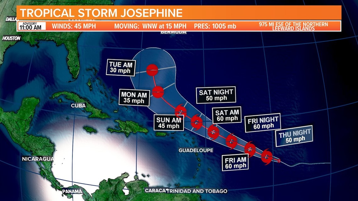
It had maximum sustained winds of 45 miles an hour, just above the 39 miles an hour needed to be considered a tropical storm. The storm was moving to the west northwest at 15 miles an hour.
On its current track, the storm does not appear to pose much of a threat to the mainland United States. The current forecast model shows Josephine moving well north of Puerto Rico by Sunday night, then curving northward as we move into Tuesday morning.
While it's still early in the forecast, most of the current model appears to keep it well offshore of the United States. That still could change.


Either way, it's going to be hard for the system to stay together due to shearing forces that it will be encountering. Some models even have the storm dissipating, but most have it staying as a tropical storm through the weekend, but then going back down to a tropical depression.
Earlier, this month, NOAA updated its hurricane forecast calling for an "extremely actived" hurricane season with 19-25 named storms, 7-11 hurricanes and 3-6 major hurricanes.
Forecasters say the possibility for an extremely active season is due to warmer normal sea surface temperatures in the Atlantic and Caribbean, an enhanced West Africa Monsoon season, a possible La Nina forming and reduced wind shear over the Atlantic Basin.


