
COLUMBIA, S.C. — High pressure will shift eastward into the Carolinas over the coming days. As it does, a much drier air mass is forecast to move into the region, particularly by Friday and into the weekend.
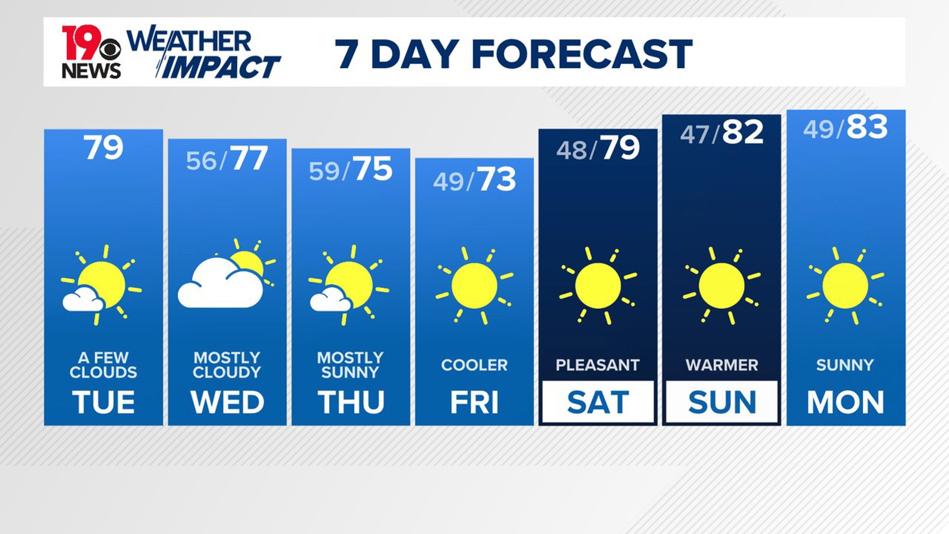
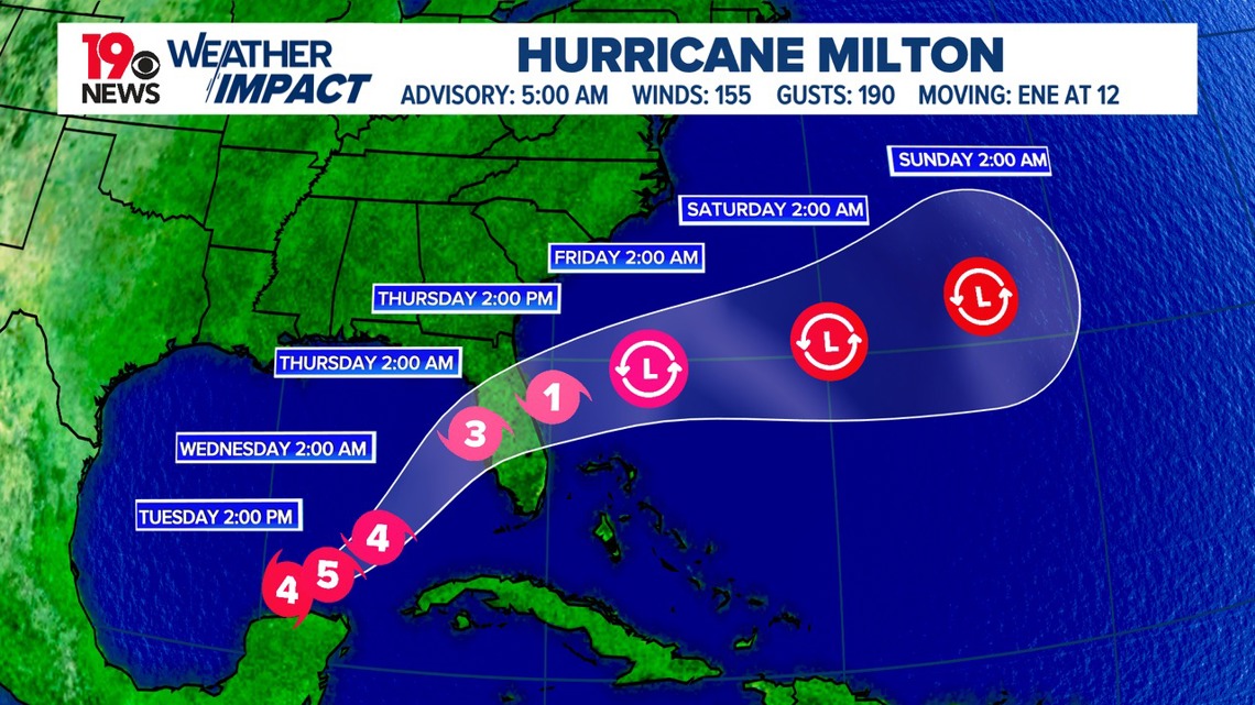
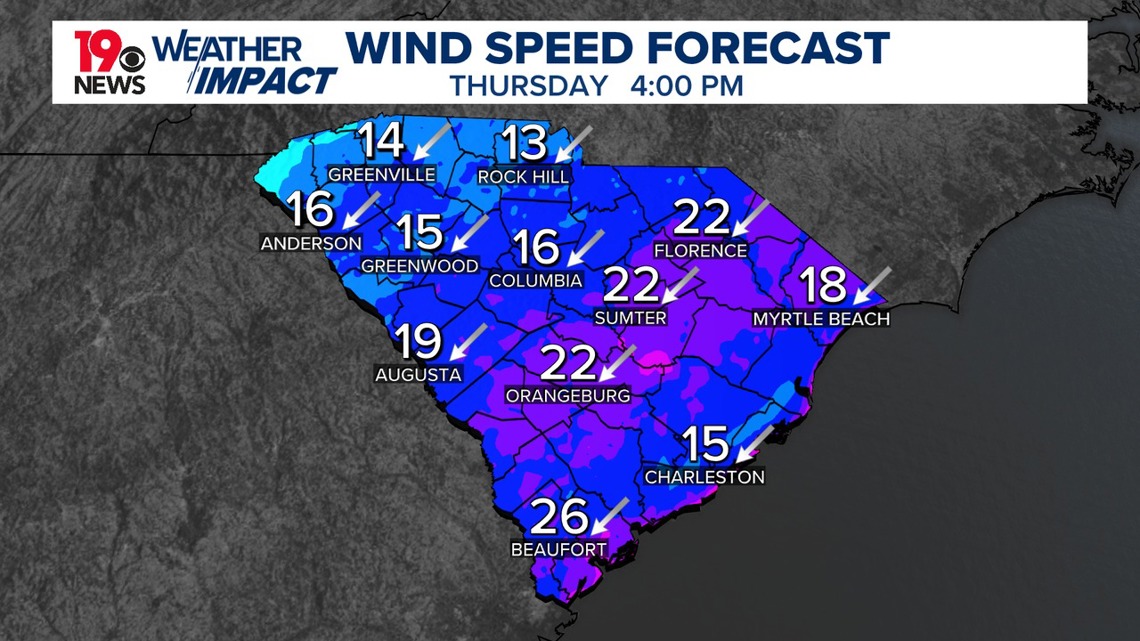
Hurricane Milton is still a major hurricane and is forecast to move over Florida, remaining well southeast of South Carolina and Georgia. Despite its distance, the storm will bring breezy conditions to South Carolina, especially on Thursday afternoon. Temperatures are expected to drop below normal by the end of the week, with cooler nighttime temperatures.
The cold front that has recently moved through the region brought dry weather, but with some unexpected, lingering showers in the northern Midlands and Pee Dee areas. These showers are now diminishing as the front continues its push southward.

Behind the front is the start of a refreshing wave of fall weather; dewpoints in the upper 40s are already being recorded in Charlotte, and this cooler air will continue to move southward over the next 12 to 18 hours.
Although it is unlikely for dewpoints to drop that low in our area today, they are expected to reach the 50s. Highs will be in the upper 70s to low 80s, with mostly sunny skies and northeast winds at 5 to 10 mph. Overnight, high-level clouds will return as Hurricane Milton approaches the Gulf of Mexico. Otherwise, expect calm weather with lows between the middle and upper 50s.

A dry and cool airmass will settle over the area, creating very pleasant conditions. Breezy weather is expected mainly Thursday afternoon as Hurricane Milton moves east-northeast off Florida's east coast. The storm will remain well southeast of Georgia and South Carolina.
On Wednesday, a surface ridge will extend into the region from the northwest, bringing dry air and seasonable temperatures in the mid-to-upper 70s. Clouds will increase Wednesday as Milton moves to our south.
As the surface ridge builds into South Carolina from the Mississippi and Ohio Valleys, drier air will continue to spread into central South Carolina, with deeper moisture remaining confined to coastal areas. Thursday will see temperatures in the low-to-mid 70s, with dewpoints in the upper 40s, and gusts of wind up to 30 mph possible in some southeastern areas.
Fall-like weather is expected to persist through the weekend. Forecasts suggest a very dry air mass will move into the region by Friday, with humidity levels very low.
Temperatures will be cooler than normal on Friday but will warm slightly into the weekend. Friday night will bring favorable conditions for radiational cooling, with lows expected to dip into the mid-to-upper 40s.