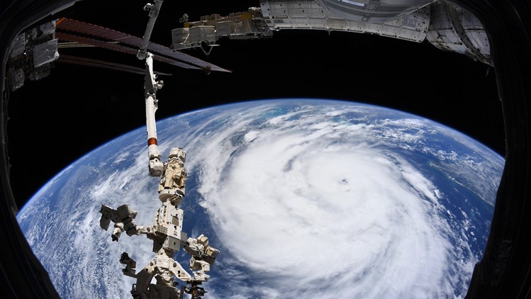
NEW ORLEANS — While photos from below are showing the true power of Hurricane Ida, one taken just hours earlier from a very different perspective shows just how massive this storm is.
The crew aboard the International Space Station has shared a photo of Ida from far above depicting an enormous white vortex. The clouds seemingly blot out the distinct color that earned Earth the nickname "Big Blue Marble" by many an astronaut.
The photo, taken by European Space Agency Astronaut Thomas Pesquet, shows the storm while it was still hours away from landfall.
NASA shared the photo, explaining that these unique observations help the agency work with the National Oceanic and Atmospheric Association (NOAA) and the Federal Emergency Management Agency (FEMA) - two groups that are already heavily involved in the response planetside.
Ida, a powerful Category 4 hurricane, officially made landfall near Port Fourchon, Louisiana, according to the National Hurricane Center.
It was a Category 4 storm with max sustained winds around 150 mph, with gusts up to 160 mph.
Official landfall occurs when the center of the eye passes over land. This ties Laura (2020) and Last Island (1856) for the strongest hurricane by wind speed to hit Louisiana. It is also the 2nd strongest hurricane by pressure at 930 mb. Hurricane Katrina was at number one with 920 mb.
There have only been 4 hurricanes on record in the U.S. since 1851 that have made landfall with 155 mph max winds before: Labor Day (1935), Camille (1969), Andrew (1992), and Michael (2019). All of those were Category 5 storms.
A Hurricane Warning has been issued for practically the entire Louisiana and Mississippi coast.