

COLUMBIA, S.C. — A front will move through the state, bringing widespread showers and storms to the Midlands of South Carolina today. The front is expected to move south of the area by Saturday, ushering in drier air and lowering rain chances over the weekend. Temperatures will hover near to slightly below normal through early next week before returning to typical summer levels by midweek.
The front, currently along the Virginia-North Carolina border, will push through North Carolina and into our area by the afternoon and evening. With precipitable water values remaining above 2 inches, heavy rain and potential flash flooding are concerns, but there are no watches in effect.


The highest storm coverage is expected in the eastern portion of the Midlands. The strongest convergence, coupled with a sea breeze, will be in this area. While the front is expected to move quickly, limiting significant flooding issues, high rainfall rates within storms could still pose flash flood threats.
An upper-level trough moving through New England will finally push the persistent frontal boundary south and west of the region this weekend. Moisture levels will drop from 1.75-2.00 inches on Saturday morning to 1.25-1.50 inches by Sunday. This sharp moisture gradient along the GA/SC state line near the boundary means a much-needed decrease in convective activity. Expect isolated storms at best on Saturday, providing a break from the recent heavy rains.

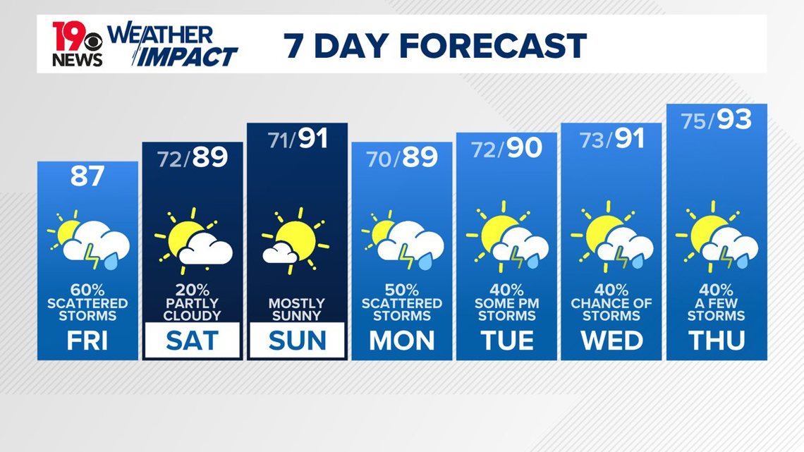
High pressure will settle over the Southeast U.S. next week, bringing a brief respite from the oppressive humidity. Without any significant forcing mechanisms, convection will mainly occur near the sea breeze front and mesoscale features like outflow boundaries. Temperatures should return to near normal for midsummer, bringing back the familiar heat and humidity.