
COLUMBIA, S.C. — Hot and humid conditions will persist today and into the weekend, making it feel quite muggy across South Carolina. As moisture builds, we will see an increase in afternoon and evening rain and storm chances. By the start of the work week, a cold front will bring slightly cooler and drier air, but temperatures are expected to climb back to near 100 degrees by mid-week due to high pressure building in.
On Thursday, a few areas were lucky enough to get some much-needed rain. High temperatures were kept down with the clouds and rain in place. Highs were in the lower to middle 90s. The Columbia airport hit 95 degrees.

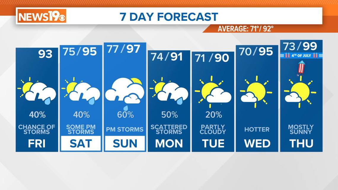
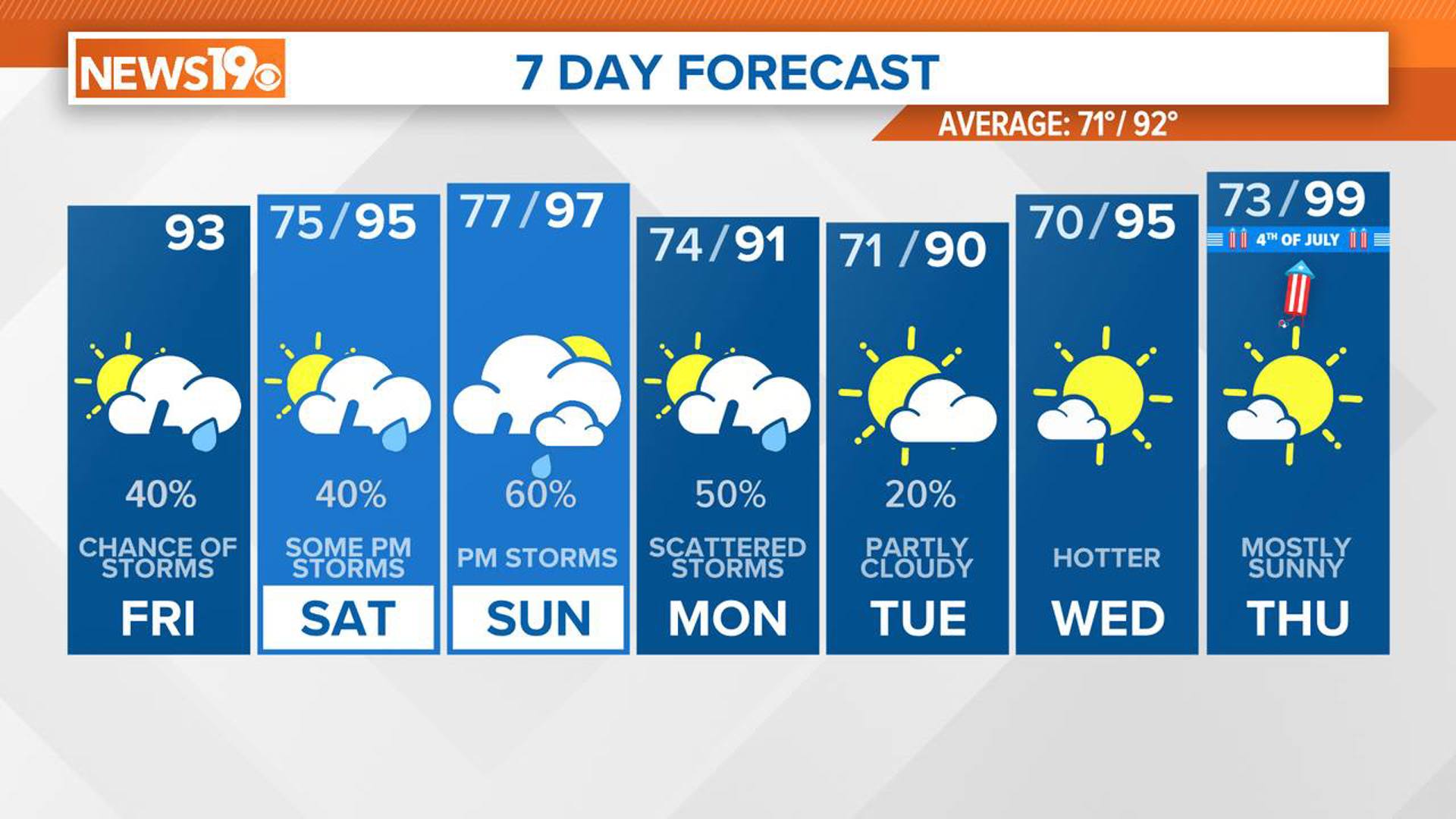
The combination of heat and humidity will keep things sticky, and scattered thunderstorms are likely to develop during the afternoons. A surface boundary in the area will help produce weak convergence, leading to enough instability for afternoon showers and thunderstorms. With the potential for slow-moving storms, periods of heavy rainfall are possible, and gusty winds can't be ruled out. Temperatures will reach the lower 90s, but it will feel closer to 100 degrees due to the humidity.
Rainfall will linger into the evening before dissipating by midnight, with the possibility of late-night fog in areas that receive rain. Overnight lows will only drop to the middle 70s.
Excessive heat will continue to be a concern this weekend, particularly on Sunday, when heat index values could reach 106–112 degrees. A heat advisory is likely, with the possibility of an excessive heat warning.
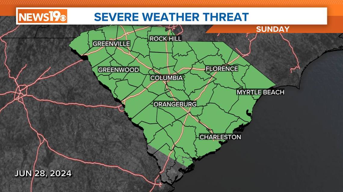
The combination of a strong upper-level trough moving through the Great Lakes and New England, along with a frontal boundary and high moisture levels, will lead to scattered thunderstorms, especially on Sunday. Locally heavy rainfall is possible, which will be welcome after a dry start to June.
The Storm Prediction Center does have most of South Carolina under a marginal risk of severe weather on Sunday.

Looking ahead, there will be a brief cooling trend from Monday through Tuesday as a frontal boundary moves south, bringing noticeably cooler air to the state. Scattered showers and thunderstorms are still possible on Monday with the frontal passage, but it should be drier on Tuesday.
However, high pressure will rebuild over the Southeast by mid-week, bringing back the heat and humidity just in time for the Fourth of July. Expect typical early-July precipitation chances during this period.