COLUMBIA, S.C. — Today, a weak cold front will pass through the area, bringing showers and storms in the afternoon and evening. Temperatures ahead of this front, however, will still reach the upper 90s, so another heat advisory is in effect today. The front will then stall across the coastal plain, but drier air will gradually begin to fill in through Friday before the heat and some elevated humidity return over the weekend.
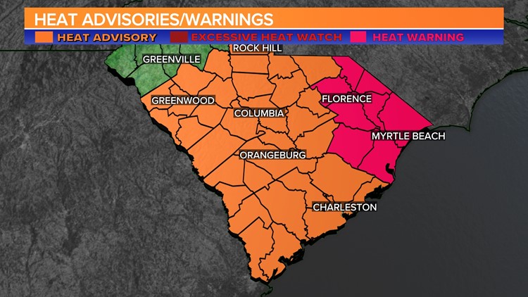
A heat advisory is in effect for the entire Midlands today. The advisory is in effect until 8 p.m. Some showers or storms will be possible later today.
The Storm Prediction Center has most of the Midlands under a marginal risk (Level 1 out of 5) for severe storms today. This means that isolated severe storms are possible. If a severe thunderstorm were to develop, the greatest danger would be damaging wind gusts.


The heat will be the day's other major weather story. This afternoon's heat index may range between 105 and 110.
When the temperature rises and the heat index rises, it is critical to prioritize your health. Here are some important heat safety tips to remember:
Stay Hydrated: Drink plenty of water throughout the day. Avoid excessive consumption of caffeinated and alcoholic beverages, as they can lead to dehydration.
Take Breaks: If you're spending time outdoors, make sure to take regular breaks in shaded or air-conditioned areas. Resting in a cool environment will help your body recover from the heat.
Dress Wisely: Opt for loose-fitting, light-colored clothing that allows your skin to breathe. A wide-brimmed hat and sunglasses can also offer protection from the sun.

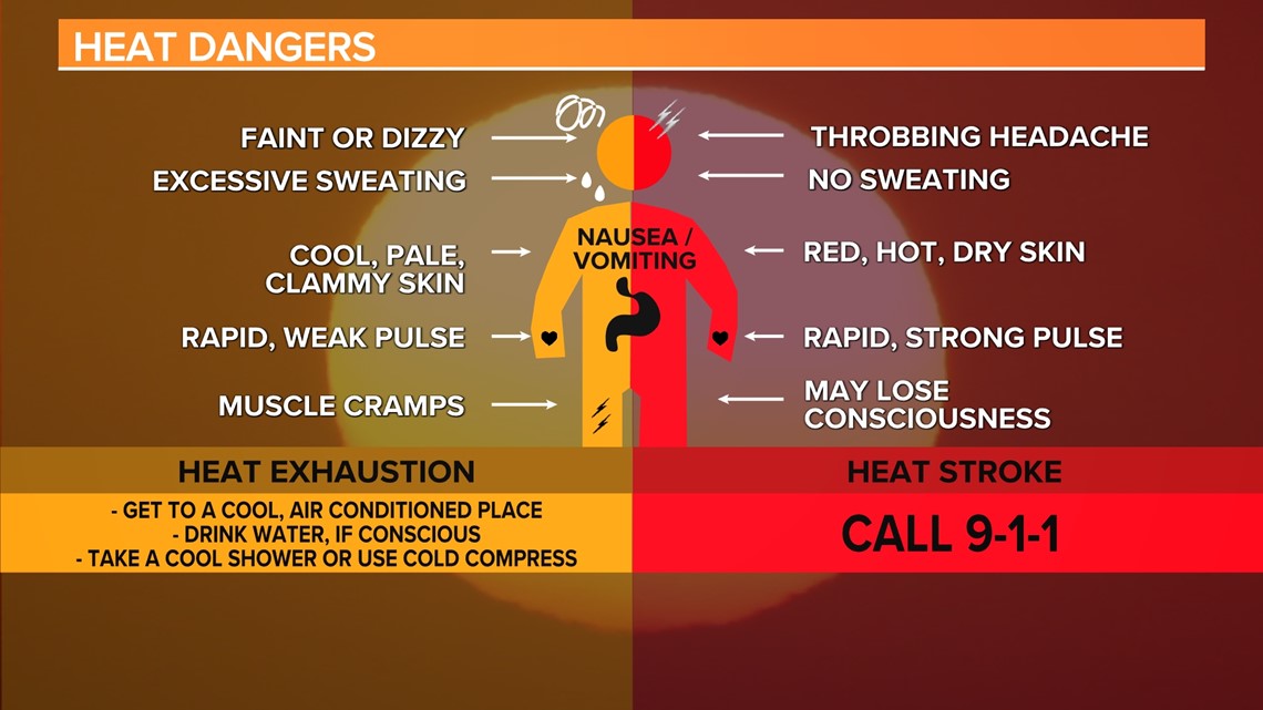
Limit Outdoor Activities: If possible, avoid strenuous outdoor activities during the hottest parts of the day, typically from late morning to early afternoon.
Use Sunscreen: Apply a broad-spectrum sunscreen with a high SPF to shield your skin from the sun's harmful UV rays.
Check on Others: Keep an eye on family members, friends, and neighbors, especially those who might be more vulnerable to heat-related illnesses, such as the elderly and young children.
Never Leave Anyone in a Parked Car: Temperatures inside a parked car can skyrocket to dangerous levels within minutes. Never leave children, pets, or anyone else in a parked car, even for a short time.
Temperatures will be seasonably hot on Wednesday. There may be a few showers or storms in the southern and eastern half of the Midlands, but the rain chances appear to be small.
Tracking the Tropics:
A tropical wave is producing disorganized showers and thunderstorms a few hundred miles west-southwest of the Cabo Verde Islands. If this system develops, it should do so slowly as it moves westward to west-northwestward at about 15 mph across the Atlantic.


A tropical wave is expected to move off Africa's west coast tonight or early Wednesday. This system may develop slowly late this week or over the weekend as it moves west-northwestward or northwestward across the eastern Atlantic. By early next week, environmental conditions are expected to become unfavorable for development.