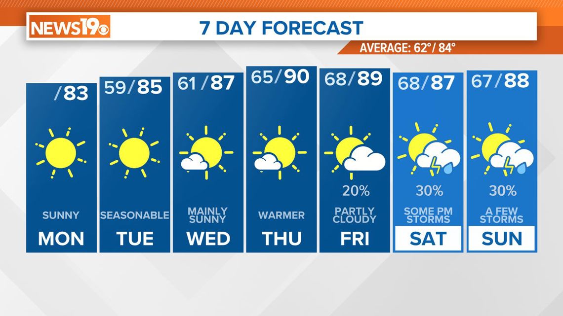
COLUMBIA, S.C. — High pressure will dominate the region through early Thursday, maintaining fair and dry weather along with rising temperatures. A frontal boundary is expected to approach the area on Thursday, stalling just to the north. This will increase the chances of showers and thunderstorms from Friday into the weekend.
Any low clouds today should dissipate by the afternoon, giving way to scattered cumulus clouds, but conditions will remain dry due to the high pressure to our north. Northeasterly winds will keep temperatures near to slightly below normal, with highs in the lower 80s under sunny skies.
From Tuesday through Wednesday night, high pressure will prevail. This will keep dry air in the middle and upper levels, while weak moisture returns to the surface on Wednesday. With the dry air aloft, expect only limited daytime cumulus clouds and no precipitation.


These clouds will dissipate by sunset, resulting in partly cloudy days and mostly clear nights. Winds will be light, around 5 mph. Temperatures will rise, with highs reaching the mid-80s on Tuesday and the upper 80s on Wednesday.
Excellent radiational cooling conditions will drop temperatures to the upper 50s to around 60 on Tuesday night, while increasing clouds on Wednesday night will limit cooling, with lows in the lower 60s.
Forecast models show minor changes, with the American model predicting a more dynamic pattern, which would lead to more rain, and the European model indicating a more zonal flow and less rain. A cold front will move toward the region on Thursday, stalling just north of the area by Thursday night and Friday.
Southerly winds on these days will bring more moisture, with precipitable water values reaching 1.25 inches on Thursday and 1.5 inches on Friday. Although the front will increase moisture, a strong trigger for widespread convection is lacking.
An upper-level trough will flatten in response to a shortwave passing north, which may generate some convection or sea breeze activity in the afternoon and evening. The highest chances of storms on Friday will be in the northern Midlands and Pee Dee regions near the frontal boundary.
On Saturday and Sunday, another upper-level shortwave will cross the area, and the pattern will return to more zonal by Sunday. With moisture remaining high, expect daily chances of showers and thunderstorms. High temperatures will be near or slightly above normal throughout the long-term period.

