
COLUMBIA, S.C. — Hot and humid conditions will continue to dominate the weather. Starting today, there is an increase in the chances of afternoon and evening showers and storms.
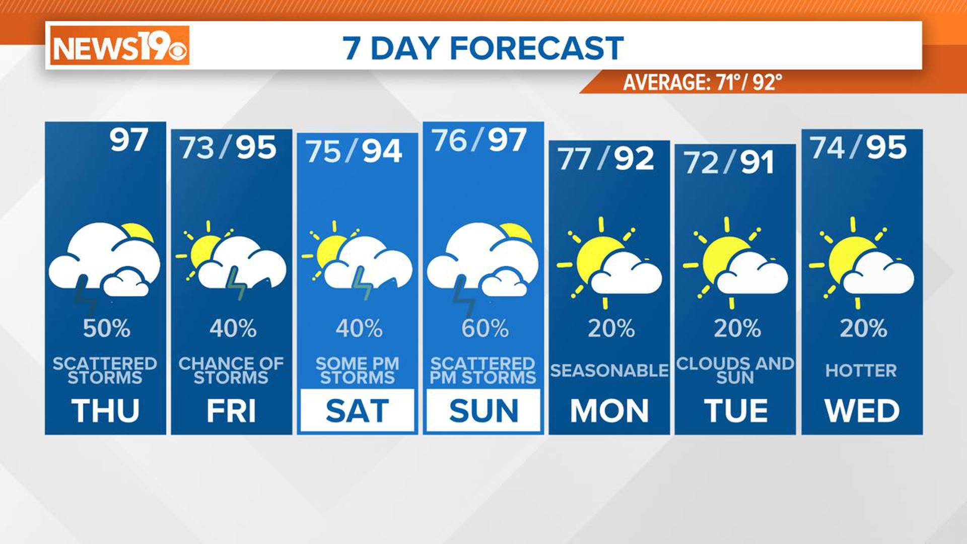
Today will remain hot and humid, with a noticeable increase in moisture leading to scattered storms in the afternoon and evening. An upper trough over the lower Mississippi Valley is pushing southward, which will bring more moisture into our area.
As a result, we can expect to see more clouds this morning, which may help keep temperatures from soaring so high. However, this added moisture will keep dew points higher than they have been in recent days.

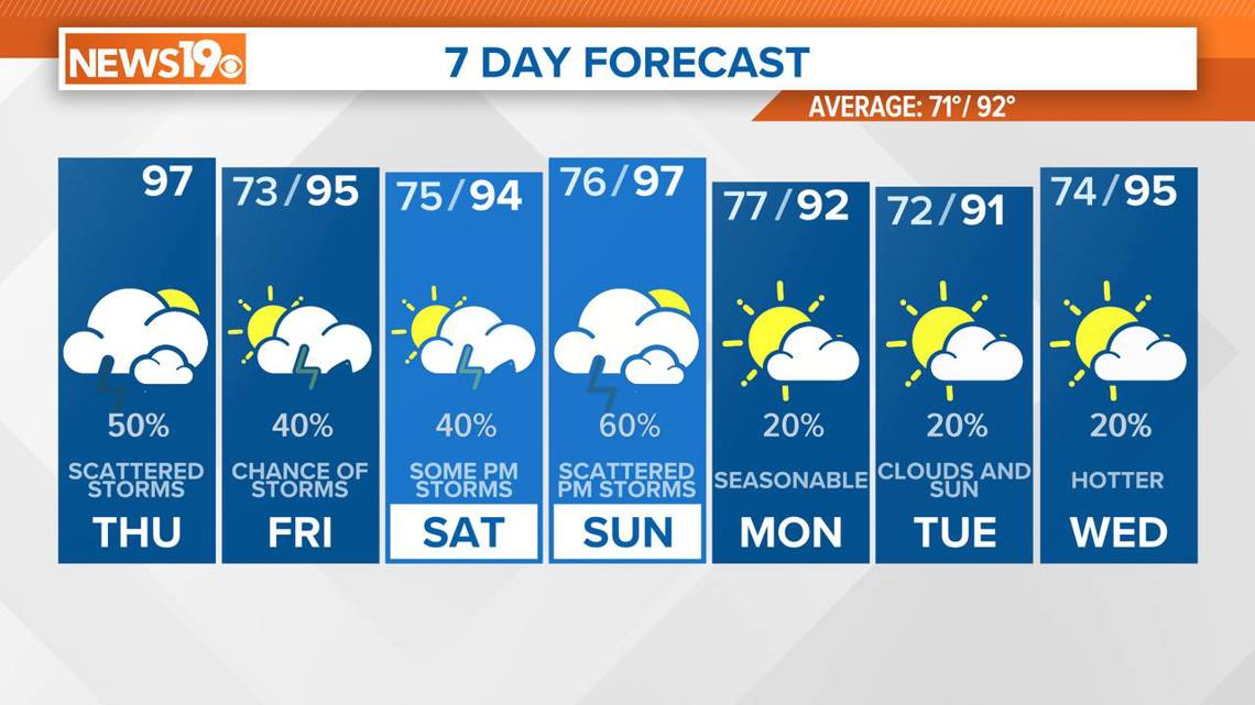
Temperatures are expected to stay in the middle to upper 90s, but with dew points in the upper 60s to low 70s, the heat index will make it feel like it is between 100 and 104 degrees. It will not reach heat advisory levels today, but it will still be uncomfortably hot.
With the additional moisture and an upper-level disturbance providing a source of lift, we can expect a higher coverage of showers and storms today. The southeastern part of the forecast area, where the moisture is highest, will see the most storm activity starting in the middle to late afternoon.

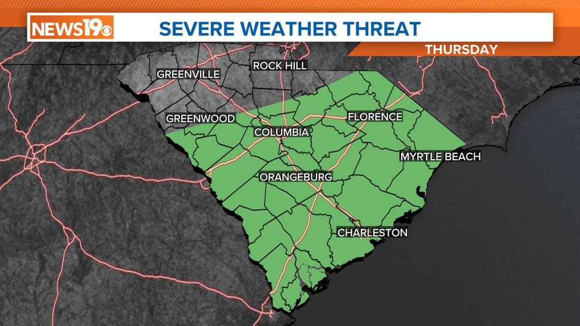
There is a marginal risk of severe weather today. The unstable atmosphere could lead to isolated strong wind gusts in the most intense storms. These storms are expected to weaken tonight, with overnight lows dropping to the low to mid-70s.
As we head into Friday, the upper trough will move through the region, making way for an upper ridge to return on Saturday. The moisture levels will continue to rise, keeping temperatures in the middle 90s. However, this will also push heat index values above 100 degrees each day. On Saturday, heat index values could approach or exceed advisory levels once again.
On Sunday, a surface front will approach the region, but it is not expected to pass through until late Sunday night or early Monday morning. Ahead of this front, temperatures will again climb into the middle 90s. Despite this being slightly cooler than recent highs, the increased moisture will push heat index readings between 105 and 113 degrees, marking some of the highest readings of the season. If these conditions persist, a heat advisory will likely be issued for Sunday.
Looking into next week, slightly cooler temperatures are anticipated on Monday and Tuesday as the upper ridge breaks down, allowing an upper trough to move through. Highs should drop to around 90 degrees before climbing back into the middle 90s by Wednesday as another upper ridge builds.
Stay hydrated and take necessary precautions to stay cool during this period of intense heat and humidity.