
COLUMBIA, S.C. — Severe weather is currently in the area as a strong cold front moves through South Carolina. A line of showers and storms pushed through during the afternoon and is expected to continue into the evening hours. Some of that weather has been severe, leading to tornado watches and warnings which have since been canceled.
However, even with some of the worst of the weather already out of the Midlands, some strong storms are still expected into the late night and early morning.
News19 will keep track of storm developments as they happen here. Check back often for live updates through the evening.
Live weather updates
7:56 p.m. | Tornado Watch canceled for Aiken, Barnwell, Fairfield, Kershaw, Lancaster, Lexington, Newberry, Richland, and Saluda counties.
7:38 p.m. | The National Weather Service reports that strong thunderstorms will impact parts of northwestern Calhoun, northeastern Barnwell, Southeastern Lexington, northeastern Aiken, northwestern Orangeburg, and south central Richland counties through 8:30 p.m. These storms will be capable of winds of up to 40 mph and hail that is up to a quarter of an inch in size.
7:29 p.m. | The Tornado Watch for Edgefield and McCormick counties has been canceled but continues for Aiken, Barnwell, Fairfield, Kershaw, Lancaster, Lexington, Newberry, Richland, and Saluda counties until 10 p.m.
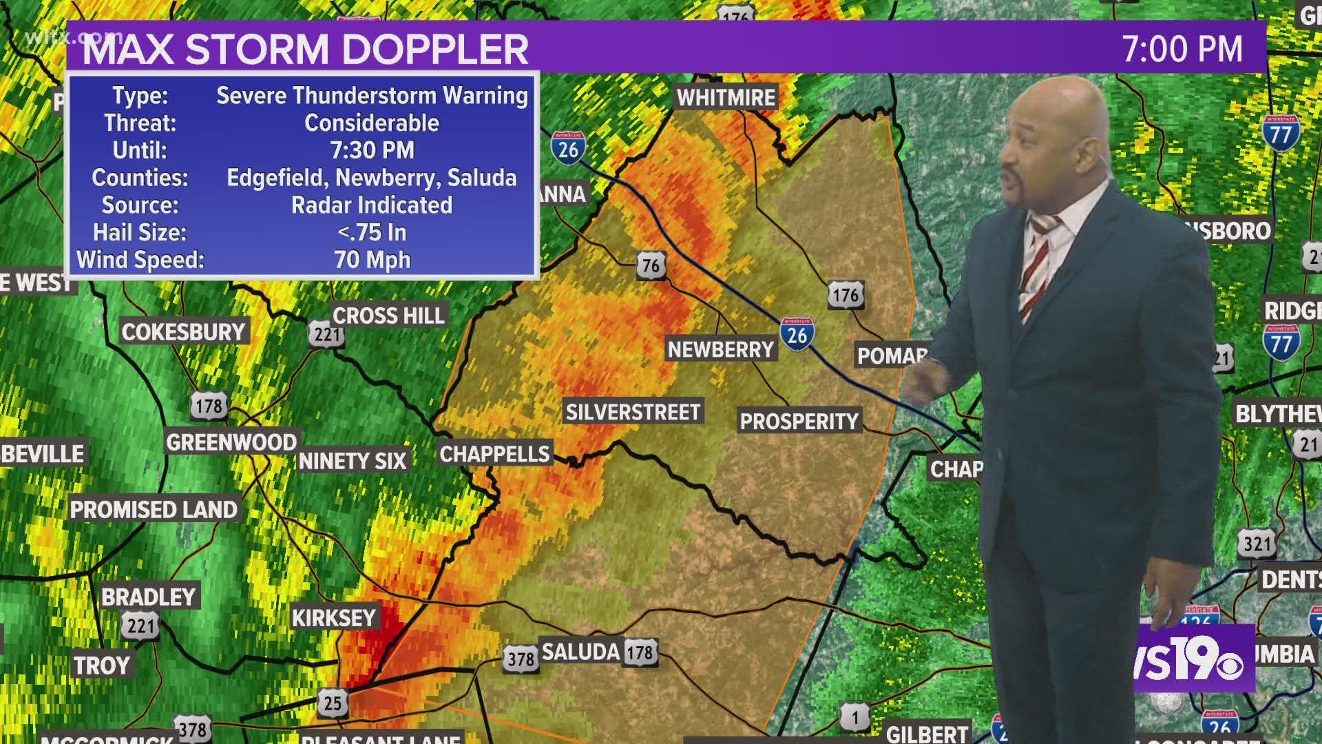
7:14 p.m. | The National Weather Service reports that severe thunderstorms were located along a line extending from near Newberry to Saluda County Airport moving east at 35 mph.
7:06 p.m. | A Severe Thunderstorm Warning for McCormick County has been canceled but continues for Aiken and Edgefield counties until 7:30 p.m.
7:27 p.m. | The National Weather Service said that 911 call centers in Newberry County have reported thunderstorm wind damage with multiple trees down.
6:56 p.m. | A Severe Thunderstorm Warning has been issued for Aiken, Edgefield, McCormick, and Saluda counties until 7:30 p.m. The storm is capable of 60 mph wind and pea-sized hail.
6:45 p.m. | A Severe Thunderstorm Warning has been issued for Edgefield, Newberry, and Saluda counties until 7:30 p.m. The storm is capable of winds of 70 mph and pea-sized hail.
6:43 p.m. | A Severe Thunderstorm Warning has been issued for Aiken, Edgefield, and McCormick counties until 7:30 p.m.
5:57 p.m. | A Severe Thunderstorm Warning has been issued for Aiken, Edgefield, McCormick, and Saluda counties until 6:45 p.m.
5:56 p.m. | The Tornado Warning for Edgefield and Saluda counties has been canceled.
5:37 p.m. | The National Weather Service has canceled the Tornado Warning for McCormick County; however, it continues until 6:15 p.m. for Edgefield and Saluda counties. This storm is capable of generating a tornado and could also bring pea-sized hail.
5:33 p.m. | A Tornado Warning has now been issued for Saluda, McCormick and Edgefield counties until 6:15 p.m. This storm is capable of generating a tornado and could also bring pea-sized hail.
5:18 p.m. | A possible tornado has been spotted near Modoc, South Carolina in McCormick County according to the National Weather Service.
5:14 p.m. | According to the National Weather Service, a trained spotter has reported a funnel cloud near Modoc in McCormick County. The spotter reported seeing a rotating wall could with a funnel over Lake Strom Thurmond moving northeast toward Modoc.
5:00 p.m. | A Tornado Warning has been issued for Edgefield and McCormick counties in South Carolina until 5:45 p.m.
4:40 p.m. | A Tornado Watch has been issued for several South Carolina counties including Aiken, Barnwell, Edgefield, Fairfield, Kershaw, Lancaster, Lexington, McCormick, Newberry, Richland, and Saluda until 10 p.m.
1:03 p.m. | Meteorologist Daniel Bonds shares the latest run of the forecast