
COLUMBIA, S.C. — This week’s weather will bring a mix of dry air and near-average temperatures, but rain chances are expected to increase starting late Thursday as moisture moves in from the southwest. As the weekend approaches, temperatures will dip slightly below normal, and rain showers will become more frequent.
For the early part of the week, surface high pressure will provide cool and dry conditions, typical of late summer. A long wave trough over the eastern United States is moving northeast, leaving northwest winds in its wake. At the surface, pressure from the Mid-Atlantic region will extend into our area, keeping things stable. Dry air will dominate, with little moisture in the region.

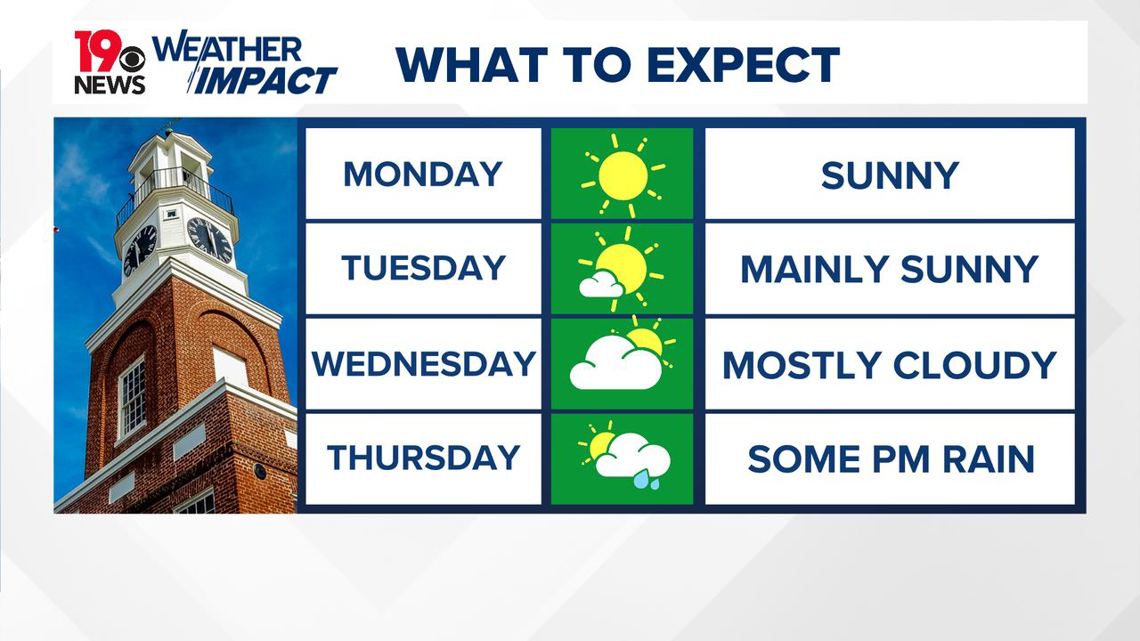
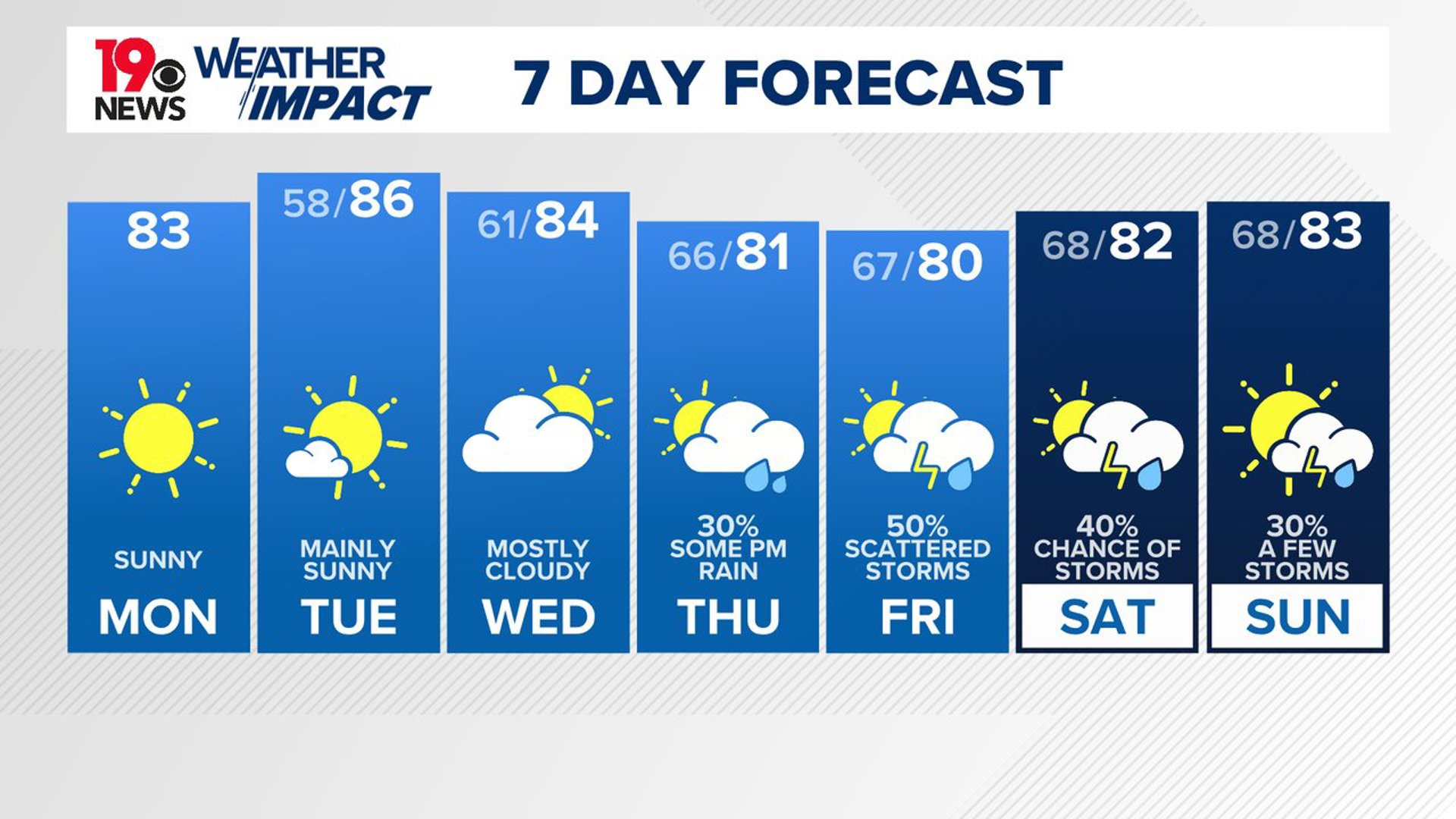
Today, you can expect sunny skies, although a few clouds might appear in the southeast. Daytime temperatures will reach the low 80s, and the air will feel cool and comfortable, with dew points ranging from the mid-50s to around 60. Tonight, clear skies will create perfect conditions for cooling, with temperatures likely to drop to the mid-50s in the northern areas and near 60 in the southeast.
By midweek, temperatures will warm slightly, with clear skies and continued dry air. On Tuesday, a ridge of high pressure will form over the southern United States, keeping the weather dry. Temperatures will climb into the upper 80s, making Tuesday the warmest day of the week.
On Wednesday, cloud cover is expected to increase, leading to slightly cooler temperatures, although conditions will still be pleasant.
As we approach Thursday, moisture from the Gulf of Mexico will begin to move into the region. A tropical system in the western Gulf will push moisture northward, although it is not expected to hit our area directly. However, it will bring increasing chances of rain starting Thursday night and continuing into the weekend.
Rainfall totals will likely remain light, with around 0.5 inches expected in some areas. Temperatures will cool slightly below average, making for a mild and damp end to the week.
Tracking the Tropics:
A developing system in the western Gulf of Mexico is expected to become a tropical storm today, with tropical storm watches already in place for northeastern Mexico and parts of southern Texas. Forecasters predict the system will strengthen into a hurricane by midweek as it approaches the northwestern Gulf Coast.

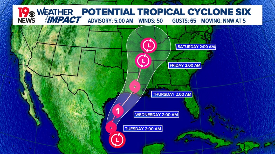
Although it is still too early to know exactly where the storm will hit, the risk of a life-threatening storm surge and damaging winds is increasing along the Louisiana and Upper Texas coastlines, beginning Tuesday night. Residents in these areas should be prepared, as hurricane and storm surge watches are likely to be issued today.
Additionally, heavy rainfall and the threat of flash flooding are expected from northeastern Mexico to parts of Texas and Louisiana through Thursday.
There are two areas being watched in the middle of the Atlantic, but they currently do not threaten any landmasses.