
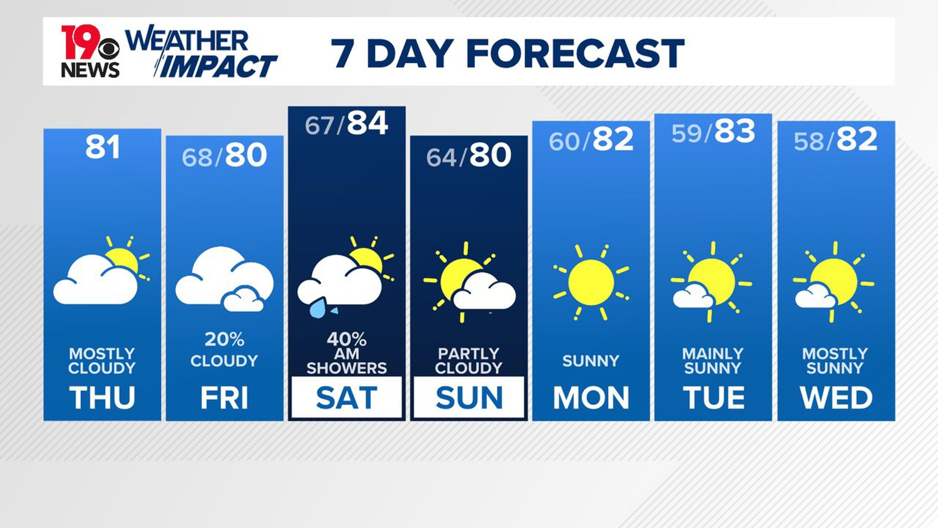
COLUMBIA, S.C. — The cooler than normal weather conditions will continue over the next several days. The chance of rain will return to South Carolina Friday night.
As we move through the week, a weak low-pressure system in the Gulf of Mexico and along the Carolina coast could bring some showers from Friday into Saturday. However, high pressure and much drier air will arrive by Sunday, bringing clearer and more pleasant conditions that could last into next week.
Clouds will cover much of the sky today, and despite increasing moisture, rain is not expected. The day will be cooler than normal, with temperatures peaking in the upper 70s and low 80s. Our average high temperature is closer to 88 degrees.

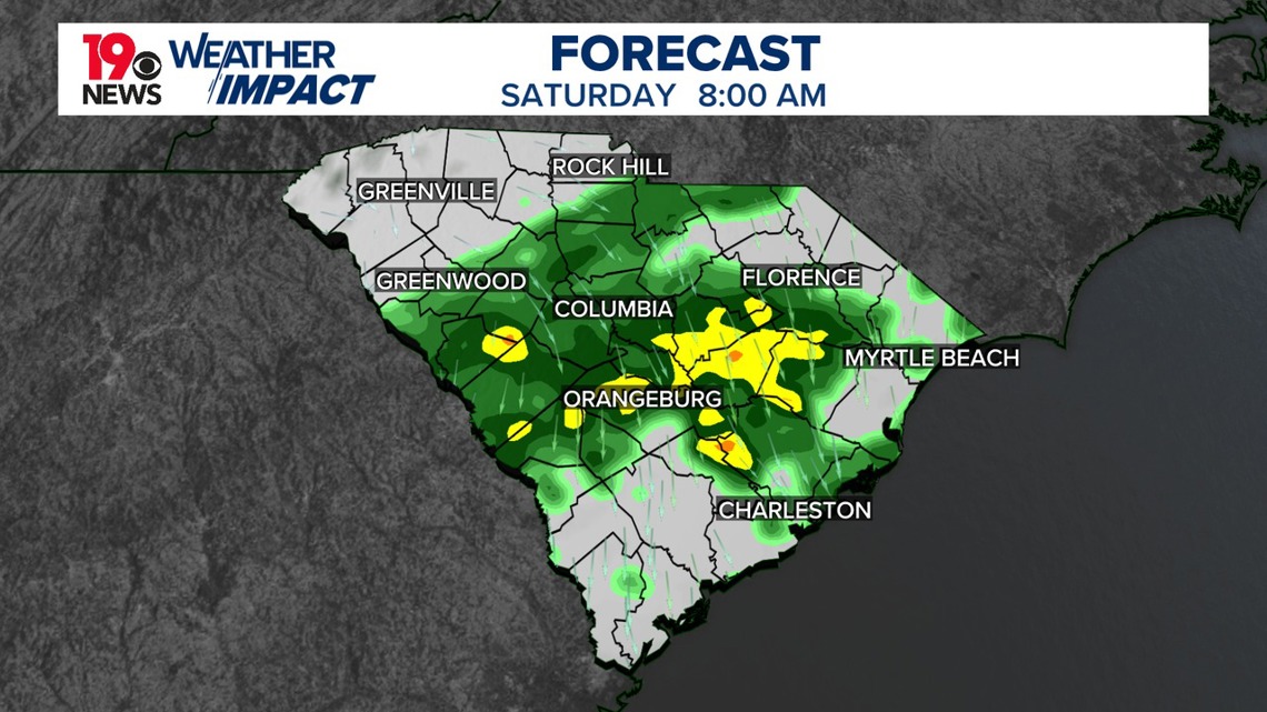
By Friday night, expect rain to develop as moisture moves in from the southwest. While forecasts differ slightly, rain totals could range between 0.25 and 0.75 inches, with some areas seeing up to an inch of rain. Temperatures will remain mild overnight, in the mid to upper 60s, with widespread cloud cover holding temperatures down during the day.
Saturday will warm up as the rain clears, especially in the western parts of the region where sunshine will return quicker. Highs could reach the mid-80s, offering a brief warm spell before cooler, drier air arrives later.
Starting Sunday, high pressure will build in behind a cold front, ushering in cooler and drier air. This shift will bring a quiet and calm weather pattern, with temperatures below normal for both highs and lows. Expect sunny skies and pleasant, fall-like conditions to settle in through midweek.

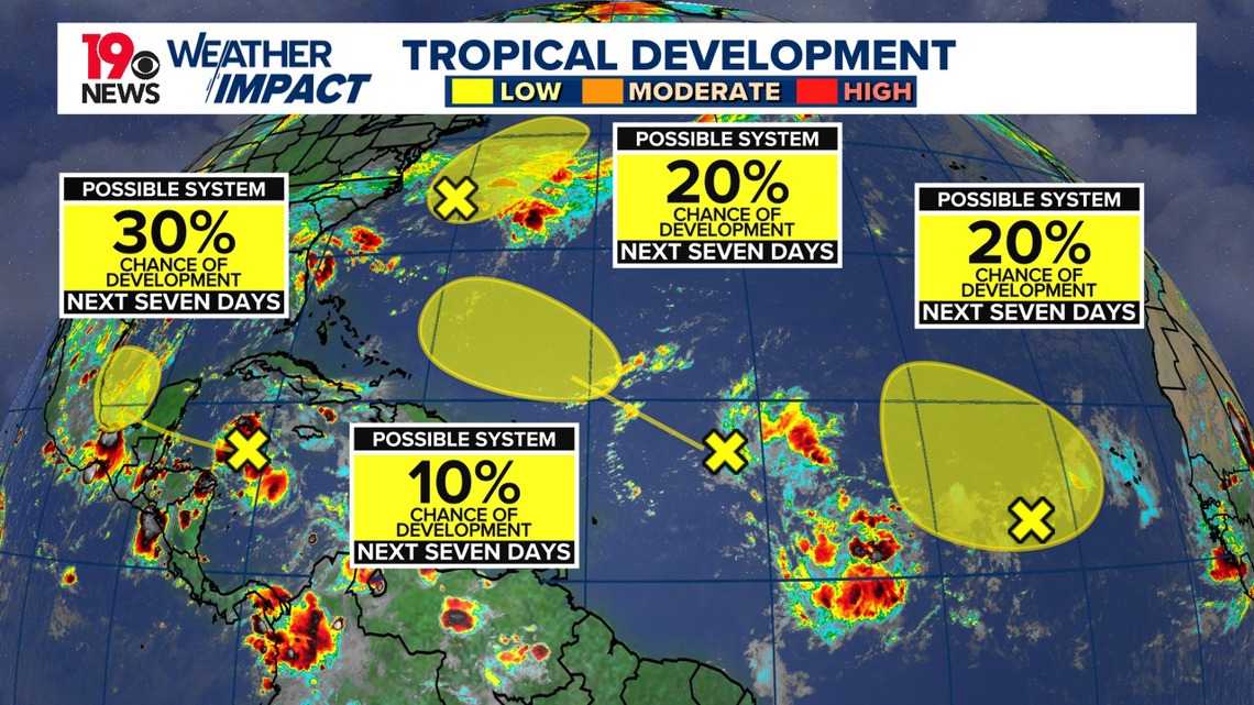
Tracking the Tropics
In the North Atlantic, Caribbean Sea, and Gulf of Mexico, several weather systems are being monitored. A low-pressure system east of North Carolina may develop subtropical characteristics but is expected to weaken after moving over cooler waters by Saturday. In the eastern tropical Atlantic, a broad area of low pressure shows limited development potential.
In the northwestern Caribbean Sea and southwestern Gulf of Mexico, a tropical wave may strengthen after crossing the Yucatan Peninsula. Finally, another tropical wave east of the Lesser Antilles is unlikely to develop due to strong upper-level winds. Overall, the chances of significant development remain low.