
COLUMBIA, S.C. — Helene is now projected to become a catastrophic Category 4 hurricane when it making landfall in Florida, upping the risk of danger to that's state's coast as well as areas well inland. At 8 a.m. Thursday, the storm was upgraded to a Category 2 hurricane.
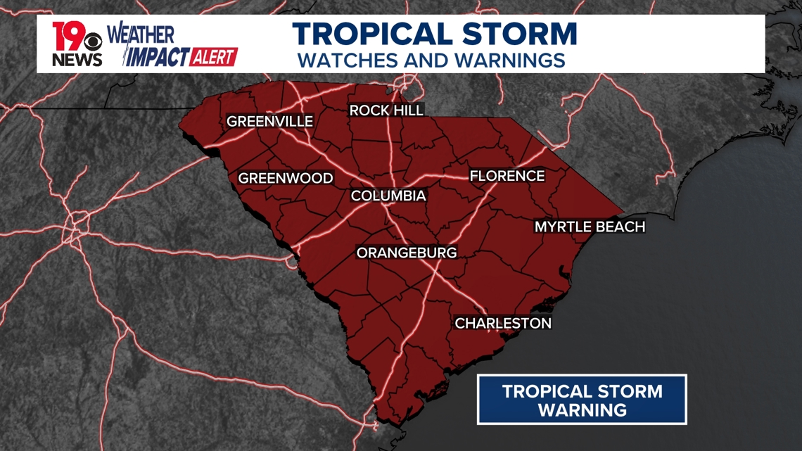
As Helene approaches the Southeast, the primary threats for South Carolina include heavy rainfall, the potential for nocturnal tornadoes, and gusty winds, especially overnight Thursday into early Friday morning. A tropical storm warning has now been issued for the entire state of South Carolina, which means there's a potential for wind 39 to 57 miles an hour.
For those reasons, News19 has issued Weather Impact Alert Days for both Thursday evening and Friday morning.
Currently, the storm has maximum sustained winds of 90 mph with higher gusts. The storm was moving towards the north-northeast at 12 mph.

WHEN:
Helene is forecasted to make landfall along Florida's Big Bend on Thursday evening before moving northwestward and approaching our area early Friday. As it continues its northward path, Helene is expected to phase with an upper low over the Lower Mississippi Valley, potentially allowing the storm to retain its structure farther inland, which is unusual for a tropical system this far from the Gulf.
Rainfall is expected to increase across the CSRA on Thursday morning and extend northward throughout the day, with the heaviest impacts likely occurring overnight Thursday into Friday morning. Fortunately, Helene should move quickly, with the center of the storm expected to pass to the west, leaving the area by Friday evening.
IMPACT:
Heavy Rainfall:
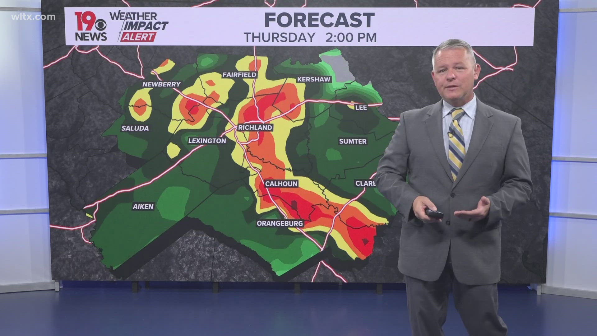
Moisture from Helene will bring high levels of precipitation, with PWATs (precipitable water values) exceeding 2.5 inches by Thursday. This will create a significant threat for heavy rainfall, especially overnight.
The heaviest rain is anticipated across the CSRA and western Midlands, with some areas potentially receiving 2–5 inches of rain, leading to localized flash flooding. While the risk of flash flooding remains isolated, the threat of river flooding increases in the days following Helene’s passage as rainwater from the Upstate moves downstream.
Nocturnal Tornadoes:
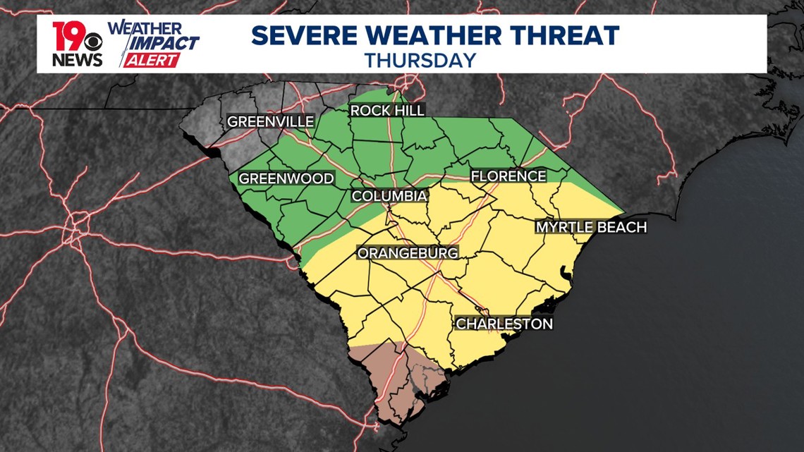
There is an elevated risk of tornadoes, especially in the early pre-dawn hours of Friday. The region is expected to be in the favorable northeastern quadrant of Helene. The greatest risk will be east of the I-20 corridor, so residents should have multiple ways to receive warnings overnight.

Gusty Winds:
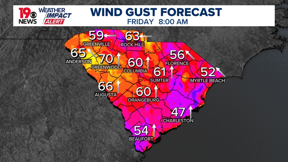
Helene is expected to bring strong winds, with gusts potentially exceeding 50 mph late Thursday into early Friday morning. The highest wind gusts are likely to occur in the western part of the forecast area, closer to the storm’s center.
NEED:
As the storm approaches, heavy rain, strong winds, and tornadoes are possible across the region. Flooding could occur in areas where rainfall accumulates quickly. Though the system is expected to move relatively fast, it may still cause significant issues across South Carolina. The storm’s interaction with a weather system to the west could keep rain showers in the forecast into the weekend.

LOOKING AHEAD:
An upper-level low will likely absorb Helene, lingering in the area through early next week. This pattern will bring continued daily chances of rain, with seasonal temperatures expected throughout the period.
Residents are urged to continue monitoring weather updates as the situation evolves and ensure they are prepared for potential impacts from Tropical Storm Helene.
Today, warm and mainly dry conditions are forecasted as the region remains under the influence of high pressure to the east. However, rain chances will increase tonight as tropical moisture moves into the area. T
ropical Storm Helene is expected to strengthen into a hurricane as it moves northward into the Gulf of Mexico. While confidence is growing regarding potential impacts from Helene, expected Thursday into Friday, uncertainties remain concerning the exact path and extent of the storm's effects.